


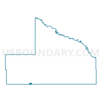
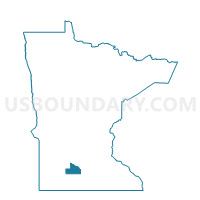
Comfrey Voting District, Brown County, Minnesota
About
Outline

Summary
| Unique Area Identifier | 601292 |
| Name | Comfrey Voting District |
| County | Brown County |
| State | Minnesota |
| Area (square miles) | 0.44 |
| Land Area (square miles) | 0.44 |
| Water Area (square miles) | 0.00 |
| % of Land Area | 100.00 |
| % of Water Area | 0.00 |
| Latitude of the Internal Point | 44.11131910 |
| Longtitude of the Internal Point | -94.90332070 |
Maps

Graphs
Select a template below for downloading or customizing gragh for Comfrey Voting District, Brown County, Minnesota


Neighbors
Neighoring Voting District (by Name) Neighboring Voting District on the Map
- Bashaw Twp. Voting District, Brown County, MN
- Comfrey Voting District, Cottonwood County, MN
- Selma Twp. Voting District, Cottonwood County, MN
Top 10 Neighboring County Subdivision (by Population) Neighboring County Subdivision on the Map
- Comfrey city, Brown County, MN (366)
- Bashaw township, Brown County, MN (243)
- Selma township, Cottonwood County, MN (193)
- Comfrey city, Cottonwood County, MN (16)